Ha Giang Province Vietnam: Geography, Culture and Ethnic Diversity
Ha Giang is the northernmost province of Vietnam, covering 7,929.48 km² with a population of approximately 870,200 people. Known for the Dong Van Karst Plateau Geopark, Ma Pi Leng Pass, Lung Cu Flag Tower, and diverse ethnic minority communities, Ha Giang is one of Vietnam’s most culturally and geographically distinctive regions.
Table of Contents
- Where Is Ha Giang Located?
- Geography and Natural Landscape of Ha Giang
- Population and Administrative Overview
- Ethnic Minority Groups in Ha Giang
- Agriculture and Local Specialties
- Wildlife and Biodiversity
- Famous Landmarks in Ha Giang
- Why Ha Giang Is Unique
- Frequently Asked Questions
- Business Directory
Where Is Ha Giang Located?
Ha Giang province is located at the northernmost point of Vietnam. It shares mountainous terrain and borders the northern frontier of the country. The capital city is Ha Giang City. The province’s geographic position makes it strategically important and symbolically significant, especially at Lung Cu, considered the northernmost landmark of Vietnam.

Geography and Natural Landscape of Ha Giang
Ha Giang covers approximately 7,929.48 square kilometers and is dominated by rugged mountains, limestone plateaus, and deep valleys. Two important rivers, the Lo River (Song Lo) and Gam River (Song Gam), flow through the province, supporting agriculture and daily life.
One of its most notable geological features is the Dong Van Karst Plateau Geopark, recognized internationally for its unique limestone formations. The province is also home to Tay Con Linh peak, one of the highest mountains in northeastern Vietnam.
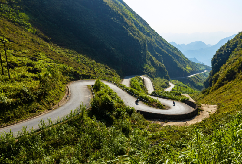
The Ma Pi Leng Pass is among Vietnam’s most breathtaking mountain roads, cutting dramatically through steep cliffs and offering panoramic views of the region.
Population and Administrative Overview
Ha Giang has a population of approximately 870,200 people (in 2019 – 2020). Despite its large land area, population density remains relatively low due to its mountainous terrain. The province includes multiple districts spread across highland and valley regions.
Ethnic Minority Groups in Ha Giang
Ha Giang is one of the most ethnically diverse provinces in Vietnam. Several minority groups live here, including: Tay people, Nung people, H’Mong people.
Each group maintains its own traditional clothing, language, architecture, and customs. The H’Mong community in particular is known for its colorful embroidered garments and strong cultural identity.
The Dinh Vua Meo (Hmong King’s Palace) represents an important historical and cultural landmark connected to the H’Mong community.
Agriculture and Local Specialties
Agriculture plays a central role in Ha Giang’s economy and lifestyle. Key agricultural products include: Corn (Ngô), Sweet potato (Khoai lang), Beans (Đậu), Local Citrus Fruit (Cam Sành) and Tea leaves.
Traditional cuisine reflects highland preservation techniques and local flavors. Popular specialties include: CơmLam (rice cooked in bamboo tubes), smoked buffalo meat (Thịt Trâu Gác Bếp). These foods represent both daily sustenance and festive traditions.
Wildlife and Biodiversity
Ha Giang’s forests and mountainous ecosystems support diverse wildlife. Species found in the region include: Peacock, Pheasant, Leopard, Snake, Pangolin
The Yen Minh pine forest is another important ecological feature, contributing to the province’s natural beauty and biodiversity.
Famous Landmarks in Ha Giang
Ha Giang is home to several iconic landmarks:
Lung Cu Flag Tower
Located at Vietnam’s northernmost point, this national symbol represents sovereignty and pride.
Dong Van Karst Plateau Geopark
A globally recognized geological heritage site.
Ma Pi Leng Pass
One of Vietnam’s most scenic mountain passes.
Dinh Vua Meo (Hmong Kings’ Palace)
A historical palace reflecting ethnic minority heritage.
Why Ha Giang Is Unique
Ha Giang stands out for its dramatic geography, ethnic diversity, agricultural traditions, and nationally significant landmarks. Its blend of natural beauty and cultural heritage makes it one of the most distinctive provinces in Vietnam.
Frequently Asked Questions
Where is Ha Giang province located?
Ha Giang is located at the northernmost point of Vietnam and borders mountainous frontier regions.
What is Ha Giang famous for?
Ha Giang is famous for the Dong Van Karst Plateau, Ma Pi Leng Pass, Lung Cu Flag Tower, and its diverse ethnic minority communities.
What ethnic groups live in Ha Giang?
Ethnic groups include Tay, Nung, and H’Mong communities.
What are Ha Giang’s main agricultural products?
Major crops include corn, sweet potatoes, beans, citrus fruit (Cam Sanh), and tea.
What rivers run through Ha Giang?
The Song Lo (Lo River) and Song Gam (Gam River) rivers flow through the province.
What is the new administrative province after Ha Giang’s merger?
In 2025, Ha Giang and Tuyen Quang were merged to form a new provincial-level administrative unit called Tuyen Quang Province
Business Directory of Tuyen Quang Province
In 2025, Ha Giang and Tuyen Quang provinces were consolidated into a single administrative unit named Tuyen Quang Province.